Our Projects
|
|
|
 |
The
Study on Mapping and Land Cover Assessment of Mangrove
Areas
The
project sites are situated in three different provinces
of the Philippines, namely, Aparri in Cagayan; Lamon
Bay in Quezon; and Ulugan Bay in Palawan.
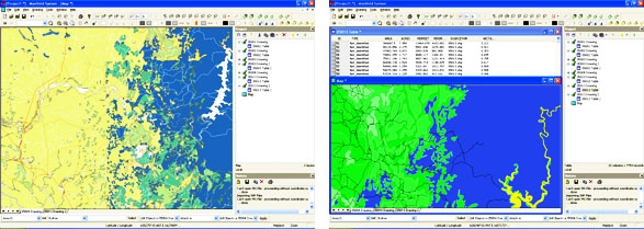
ArcView GIS Database
The graphical database constructed from the digitized
design files were imported into the ArcView format
to provide a connection between the graphical data
(maps) and its inherent site information. An attribute
database for the whole project was done using the
Microsoft Excel application. One database contains
all the information pertaining to the economic situation
of the project site. The work item includes the
following:
- Base
Maps/Index Maps
The original base maps and index maps for all
locations were digitized in MicroStation using
flatbed digitizing tablets. These digital drawings
contain all the planimetric features as they appear
on the original maps. Each map attribute (i.e.
roads, text, river, forest areas, etc.) was encoded
using its own corresponding properties like color,
weight, level, etc. Polygons were generated for
land use features and political boundaries.
- Scanned
Photographs
Photographs taken during the fieldwork for the
various sites were scanned to produce a digital
image. These scanned images were incorporated
into the ArcView database for reference.
» back
to top
|
|